![Middle East Classic Map [Laminated] - Reference Maps](https://m.media-amazon.com/images/I/81T56aS90VL._AC_SL3840_.jpg)

Middle East Classic Map [Laminated] - Reference Maps
Product ID: 66710803
💧Durable laminated finish
📏1in = 96 miles scale
🗺️18 countries detailed
Buy anything from 5,000+ international stores. One checkout price. No surprise fees. Join 2M+ shoppers on Desertcart.
Desertcart purchases this item on your behalf and handles shipping, customs, and support to KUWAIT.
🗺️ Navigate the Middle East like a pro — don’t just know it, own it!
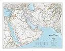
This laminated Middle East Classic Map offers detailed political markings across 18 countries, scaled at 1 inch to 96 miles, and measures 23 by 34 inches. Designed for durability and clarity, it’s an essential tool for professionals, educators, and geography enthusiasts seeking a reliable, long-lasting reference.
| Best Sellers Rank | 2,769,971 in Books ( See Top 100 in Books ) 2,922 in Earth Sciences & Geography References 4,074 in Historical Atlases & Maps 4,883 in Geography References |
| Customer reviews | 4.7 4.7 out of 5 stars (84) |
| Dimensions | 76.84 x 59.69 x 10 cm |
| Edition | 2018th Student ed. |
| ISBN-10 | 0792250222 |
| ISBN-13 | 978-0792250227 |
| Item weight | 500 g |
| Language | English |
| Print length | 1 pages |
| Publication date | 1 Aug. 2018 |
| Publisher | National Geographic |
| Reading age | 8 years and up |
M**Y
The product arrived in perfect condition.
For research on the Desert Shield / Storm
M**T
A Troubled Part of the World
Where does the Middle East begin and where does it end? I would have thought that Egypt's western frontier would have been included and I was surprised to find that the whole of Pakistan was included. However Pakistan is not the Far East; perhaps it would come under the classification of the Indian sub-continent. The map was helpful for the purpose I wanted it; viz. talks on the Christian Churches of the Middle East. Patrick Nuttgens
G**H
How big is it, what are the dimensions, does "LAM MAP" mean it is actually laminated?
Description, dimensions, lacking
J**G
I believe its copyright was 2018 but everything is pretty much correct. I like that it has clear topography and little things like the oil wells and deserts.
M**A
l'abbiamo comperata come regalo, é arrivata in tempo, molto bella(anche se leggermente piccola) e i colori sono intensi. Ce l'abbiamo da quasi un anno ed é come nuova
C**E
We needed a map of the Middle East to help show where a loved one was deployed. It was a very accurate map and we where able to use it as an add for showing our children. It helped them visualize a hard concept. The map had a great lamination on it so I was able to add post-it note arrows to help mark special locations without ruining the map.
N**A
na
H**W
Highly detailed and visually attractive laminated map!
Trustpilot
1 week ago
2 weeks ago