Some deliveries may take a little longer than usual due to regional shipping conditions.

DOWNLOAD THE APP


Customer Services
Copyright © 2025 Desertcart Holdings Limited
DOWNLOAD THE APP

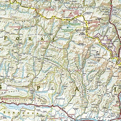
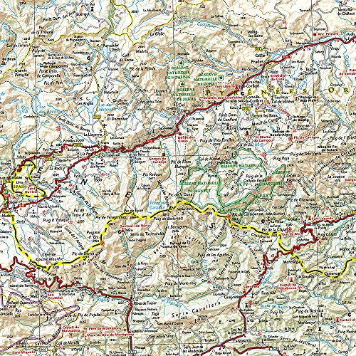
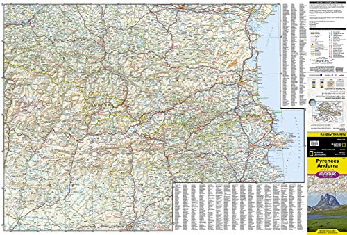
Pyrenees and Andorra Map (National Geographic Adventure Map, 3308)
L**E
Great map. Scale of 1:275,000.
The scale of this map is 1:275,000 (wish it would be mentioned in description) which is perfect for planning/traveling by bicycle or car in the Pyrenees. Of course, not detailed enough for hiking as you would need a local 50,000 or 25,000 map for that purpose.The roads are well detailed from red (major) to yellow to white (smallest) with all towns & mountain pass mentioned.For more detail I would recommend using Michelin map 342 Hautes-Pyrenees/Pyrenees Atlantiques 1:150,000 and Catalunya Geo/Estel 1:250,000,perfect for driving/cycling.For one map though this is perfect especially since it is waterproof.
L**R
Covers a Lot of Ground
Scale's a bit large to be totally useful, but give a good overview perspective of the region.
F**N
OK
Okay but had to buy additional maps with hiking trail map details for trailheads and smaller roads too hiking the Pyrenees
Z**E
National Geopgraphic does pretty much everything well
I love the paper this is printed on, think it may hold up well. The detail seems pretty amazing- I can't wait to get over there!
S**2
Great Map
Great map with lots of detail! The finish is good too. This is a comprehensive map that will not rip easily.
M**F
Not really a map of Andorra
I generally like the Nat Geo maps and have many for the National Parks. I’m planning on hiking in Andorra so when I saw this one, I was excited. However, when it arrived, Andorra was represented by and area of about 3” x 4” or about 1% of the total map area. Quite useless.If you want the best topo map of Andorra, you need the Alpina 40. It is listed on Amazon, but not in stock. Shop elsewhere if necessary, but don’t settle for anything else.
A**R
need details!!!
Not a very detailed map and very hard to plan trips with as it leaves out so much.
D**N
One Star
Not a large enough scale for any but the most main roads.
T**S
Touring the Pyrenees.
The best I can say about this map is that the quality of the material is very good. I know that there is a lot to fit in to a small space but the detail is so small I had to use a powerful pair of reading specs to decipher it. The detail is good. The biggest problem with this map is that it has no overlap, so when planning a route that requires turning the map over, it is very difficult to find the continuation point.For planning a touring holiday in the Pyrenees, I found it disappointing.
J**C
Good tough map
Good map for motorbiking, tear and waterproof paper, good scale, stands up to the abuse of being folded in all the wrong places and shoved in a tank bag.
D**N
Good coverage and decent scale for most purposes
Good coverage and decent scale for most purposes. I needed a bit bigger scale to be honest. I got maps which suited me better from the Map Shop in Upton on Severn
C**K
Good stuff
Highly recommended if your doing a motorcycle tour. Wet and tear resistant. Ideal for tank bag.
D**N
I have easily cross referenced it with DK's Backroads France
Invaluable for planning my motorhome trip along the Pyrenees later this year. I have easily cross referenced it with DK's Backroads France.It feels quite strong, and is claimed to be waterproof and tear resistant, so am expecting it to have heavy use and last the trip.
Trustpilot
3 weeks ago
4 days ago